
Tohoku-oki tsunami of 11 March 2011 | Two years on
Monday 11 March 2013 marked the second anniversary of the magnitude 9.0 Great Tohoku earthquake and devastating tsunami that struck the east coast of Japan.
Professor Dave Tappin discusses the present state of tsunami science and mitigation efforts two years after the Tohoku-oki tsunami, where around 18 500 people were reported dead or missing, and nine years after the Indian Ocean (Boxing Day) tsunami, where over 220 000 lives were lost.
How has our understanding of tsunamis advanced since these events?Where we are with response and mitigation?
Where we still need to go to ensure that the massive loss of life associated with these tsunamis does not happen again?
Where is Japan now?
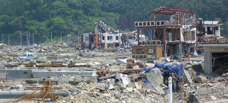
Japan is still recovering — but slowly. I was last there in February 2012, and will be returning in April 2013, so I haven’t seen at what stage the recovery is at present.
I did some internet research on Thursday 7 March to find out. However, to my surprise, i found very little new information on what is happening with the recovery.
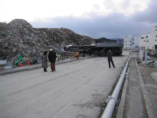
Most recent news is actually on the debris (1.5 million tonnes of it) that was flushed out to sea and has been travelling slowly eastward when, towards the end of 2012, it began washing up on the US coastline 8000 km away.
The debris included fishing boats (that the US navy sunk) and a giant floating dock. There is now a great deal of concern over species invasion of the US from the organisms attached to the floating debris.
The focus also seems to continue on the tsunami impact on nuclear power plants. In the middle of 2012, a Japanese Government report concluded that the disaster at the Fukushima nuclear plant was ‘a profoundly man-made disaster’, blaming both government and the plant operator Tepco.
This of course raises serious issues on not only how nuclear operators design their plants where there is the risk of tsunami inundation, but on what scientific data is available to help them (discussed further below).
I am attending a meeting in Japan on this subject in early April 2013, contributing to the scientific perspective on the importance of tsunami-related science data that is available to the formulation of locally appropriate engineering strategies.
Although the Fukushima power plant was built before much of our recent understandings were developed, there was adequate time before the 2011 tsunami to address these.
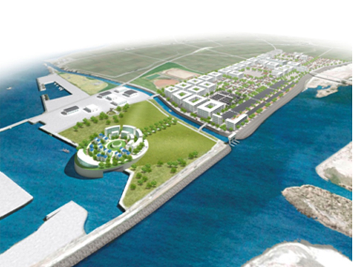
With regard to the immediate post-tsunami clean-up, the government response has been amazingly efficient. During the meeting I attended in February 2012 there were many talks on the plans for reconstruction, with many ideas on rebuilding coastal defences and in low-lying vulnerable areas ‘high-rise’ solutions.
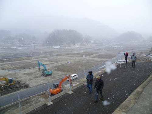
More recent information on progress on reconstruction seems hard to come by. Thousands of people lost their homes in the tsunami, but it seems from a report that came out on Thursday 7 March 2013 that many are still living in temporary accommodation.
Winters in the tsunami-affected area are very cold. I was out there in February 2012 and we were almost stranded overnight in a snowdrift.
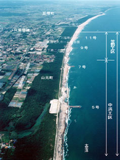
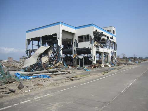
The Miami Herald article reports that many of the devastated areas are wastelands – cleared of debris, but still bleak wastelands. In Rikuzentakata city, located in the north of Honshu Island, 6000 out of 8000 homes were destroyed; rebuilding here has barely begun.
Where to rebuild?
There are obviously many difficult issues to address; for example where to rebuild; in the same — possibly threatened locations — or on higher ground?
There are also the costs to consider. The government plans to spend $269 billion on recovery, but less than $85.7 billion has been spent.
After the 2004 Indian Ocean the amount of aid money donated was so large governments found it difficult to spend.
In northern Japan, many areas in the north are remote, and there is a shortage of manpower. A colleague informed me that there is a shortage of concrete — hard to believe — I know. Talking to my Japanese colleagues in 2012, there were also difficult problems addressing those who wished to return to their previous home locations — such a fisherman in Minamisanriku who wished to be close to the sea — and those who didn’t.
What lessons have we learned?
Frankly it is hard to say. There has been a great deal learned scientifically on tsunami over the past 15 years.
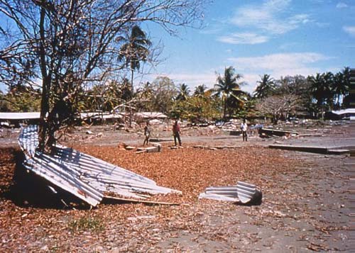
For example, we now recognise that submarine landslides can generate devastating tsunami because in 1998, off of northern Papua New Guinea, an underwater landslide caused a tsunami that killed 2200 people on the adjacent coast. I led the research on this event.
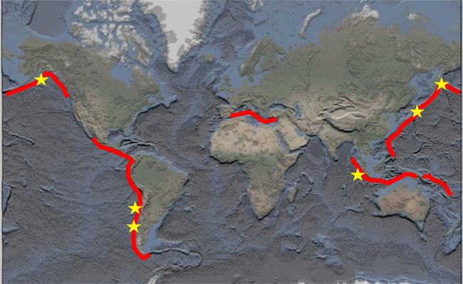
After the Indian Ocean tsunami in 2004 there was a realisation that our understanding of where these great earthquakes that generate devastating tsunami occur was massively flawed.
Previously it was understood that these earthquakes would only occur in certain regions of the Earth and the eastern Indian Ocean was not one of them.
We now know that this is not the case — many other areas are now recognised as threatened. A problem is that many of these areas — the convergent margins — are poorly researched. In fact scientists are now completely rethinking their ideas on the driving forces that cause these earthquakes and their associated tsunamis.
Warning systems
Whereas there has been a warning system in the Pacific Ocean since 1946, there was none in the Indian Ocean in 2004.
If a tsunami warning system had been present in the Indian Ocean it would probably have saved the lives many of those who perished in Thailand, Sri Lanka and India, possibly100 000 people.
In the ‘first world’ there was also the realisation that these events do not just happen to other people — 150 UK citizens died in the 2004 tsunami, it was the worst natural disaster ever to have affected Sweden — 550 of their nationals died too.
Recently I watched the film, The Impossible, based on a real life story of a family who suffered terribly during the tsunami, but against all odds survived.
There have been many good reviews — my feeling watching it was that it just shouldn’t have happened to them.
Even with a warning system in the Indian Ocean, coasts close the tsunami source — such as on the northern tip of Sumatra (where 120 000 people perished) — would have been struck very quickly allowing little time for warning and evacuation.
But those farther away — for example in Thailand, Sri Lanka and India were maybe two hours tsunami travel time away. Thus a warning would have saved many lives in these countries if suitable evacuations had taken place.
So there are three main aspects to our improved understanding from the 2004 tsunami:
- better science
- effective warning systems
- incentive to act on such warnings given recent history
Unfortunately, even though there are many positive aspects of tsunami mitigation in Japan, I always look on the 2011 tsunami from the perspective that 200 000 lives were saved rather than 19 000 lives were lost — the tsunami mitigation in operation on 11 March 2011 did not take account of the scientific lessons from the Indian Ocean 2004 tsunami about where great earthquakes may strike.
History of tsunami
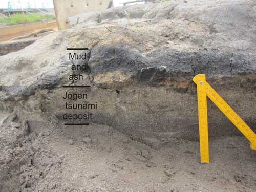
In Japan, there was local evidence that a similar magnitude earthquake and associated tsunami took place in AD 869 along the same coast.
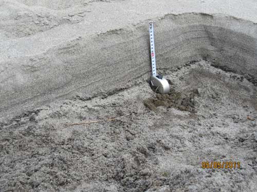
This local evidence was in the form of sediment deposited as a tsunami flooded over the land. This is quite normal and if the sediment is preserved it provides a record of older events that in some places (such as in the north-east Pacific) goes back for thousands of years.
In Japan, the AD 869 tsunami was recorded by such sediment that was buried and preserved (Figures 10 and 11). In 2001 it was discovered by Japanese researchers and dated, and the conclusion drawn that the tsunami from which it was laid down was very large — probably of a similar magnitude to that of 11 March 2011.
Lessons learned
So regarding lessons learned, I am uncertain. I mentioned the impact of the Indian Ocean event on ‘first world’ countries such as the UK, and certainly here there is a knowledge that UK nationals who travel overseas, especially on holiday, maybe at risk.
I now have an excellent relationship with the UK Foreign and Commonwealth Office (FCO), advising them on the tsunami hazards. They even conduct artificial scenarios in tsunami impact to test their response to a potential major event. There are now (or almost now) tsunami warning systems in all the world’s oceans — that in the Caribbean will be soon operational.
Where will the next big one strike?
But the real test is when and where the next large tsunami strikes. It is likely it will be at an unexpected location. This is the problem with low frequency — high impact natural events such as tsunamis.
Tsunamis are completely different to storms, for example, that occur regularly and with which there are days of warning e.g. Hurricane Sandy that struck the US in 2012.
The problem is getting the message across that tsunamis will occur, and that although the likelihood may be vanishingly small, when they strike they may be devastating.
Long travel times
Another aspect of warning is that the ocean basins are all different sizes: scaling downward from the Pacific, to the Caribbean and Mediterranean. I mentioned above that a warning system in the Indian Ocean in 2004 would have alerted the authorities of countries with coasts distant from the tsunami source that there was probably an emergency.
Today warnings of tsunami can be issued as fast as 15 minutes after the source earthquake has been identified. If the countries in 2004, in the eastern Indian Ocean, had had an effective response those coasts could have been evacuated. In the Pacific a tsunami generated from an earthquake in Chile takes 22 hours to travel to Japan – thus there is adequate time for warnings to be given.
Short travel times
By contrast the Mediterranean is very small, thus travel times from source to impact will be very short. Thus warning times will be very short, which is a major problem that still has to be addressed.
With the Japan 11 March 2011 tsunami, the earthquake warning was broadcast within three minutes, with the tsunami warning following nine minutes later (12 minutes after the earthquake).
The first coasts were struck maybe 20–30 minutes after the earthquake. Japan has the most sophisticated warning system on Earth — unfortunately, however, the magnitude of the earthquake and hence the tsunami was severely underestimated as discussed above.
Other tsunami sources
Another major issue, on which there has as yet there has been little discussion, is the other sources of tsunami that are recognised: from submarine landslides and volcanic eruption and collapse.
Today’s warning systems are only based upon earthquake tsunami generating mechanisms. There has been little consideration of how to warn against these other sources.
For submarine landslides this is understandable as we still know little about them; I mentioned above about the devastating tsunami in 1998 that struck northern Papua New Guinea. The PNG event was a wake-up call, but we still do not know the ramifications.
There are submarine landslides now identified on all ocean margins. On the continental slope, many are climate controlled and many are probably triggered by earthquakes, but we still know little about them or their hazard. Another major problem is that although many submarine landslides are mapped, e.g. in the north Atlantic, very few are dated.
Volcanic sources
Volcanic tsunami source mechanisms are a little easier to understand because, compared to submarine landslides, we better understand volcanic mechanisms.
How to prepare for the unexpected
My concern is that in countries where there has been no recent large tsunami, even if there is a warning, the response might not be as effective as in countries where there has been a recent event, because the coastal communities may not be prepared.
Thus it is not just the warning of a dangerous tsunami, this is only one aspect of the mitigation. Once a warning is given, local communities have to react, and to know what to do.
Usually the warning is issued from a central location (for example in the Pacific this is in Hawaii) to local (usually government or local government) authorities who then pass on the message to local communities.
All this has to take place in real time. For people to react they have to know what to do, thus they need be trained.
This training happens in Japan, because it is a country that experiences tsunami regularly. The problem is along in ocean margin countries where tsunamis are infrequent or where no recent large events have taken place — such as the Mediterranean or the Caribbean.
Where do we go now?
As a scientist, I believe we have to continue investigating the causes of tsunami and improve our understanding of where they may occur and their possible size.
The most common cause of tsunami are earthquakes, and although I have been rather pessimistic in the outlook presented above, there are some positive aspects.
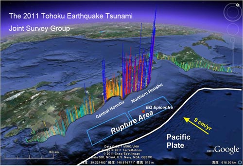
The recent events of 2004 and 2011 have been recorded with a global array of modern digital seismographs, thus we have an improved knowledge of earthquake rupture mechanisms that allow us to better understand how they may have generated their associated tsunami.
We also know generally the geographic locations where large tsunamis may occur — along the edges of continents — many of which are convergent margins.
Knowledge communication
As importantly, scientists need to communicate their knowledge to organisations involved with mitigation and response. This should be at all levels, from central government to NGOs.
Until recently my research has been mainly based on marine mapping, acquiring data from ships on the seabed morphology and what lies beneath the seabed — I was one step removed from seeing at first hand the actual impact of a tsunami on land.
After the 2011 Japan tsunami I visited Japan as part of an international research team to investigate the sediment laid down by the tsunami and the actual impact of the tsunami on the coast.
UK relevance
Subsequently, I organised a UK workshop to determine whether science was used here in pre-planning tsunami mitigation and response. After my visits (I have been three times) and the realisation that all the science available on tsunami hazard was not used in mitigation.
This may sound rather unnecessary because the risk of a major tsunami striking the UK is low, but not completely impossible.
However, as seen above, the UK government is interested in tsunami hazard, especially those ministries and departments responsible for nationals travelling and living overseas, and those responsible for aid to areas devastated after an event.
In addition, the UK is a base for many non-governmental organisations (NGOs) who respond to natural disasters overseas. The workshop was attended by 42 participants from science, engineering, Government and NGOs, and not just those UK-based, we had visitors from Pakistan, Singapore and the USA.
During the workshop, we spent two days discussing what scientific data is available and how it was utilised. The outcome of the workshop in the context of the Japanese 2011 experience, proved that there is a great deal of scope for improved communication between scientists and those who could use science in response or mitigation.
A second workshop is now planned for early 2013 where the workshop recommendations can be further discussed and implemented.
Communicating the science of tsunamis
At the present, communication of scientific research to organisations which can use it has become an important part of my work. So I plan to continue (with colleagues) the work on communicating the science of tsunamis to those who need to use it — I give many public understanding of science lectures.
There are many aspects to this, with synergies between what may appear at first sight incompatible sectors e.g. the reinsurance industry and NGOs. I also plan to continue researching the science of tsunamis; at present I have a proposal submitted to NERC for funding to investigate volcanic tsunami hazards in the Mediterranean.
My particular field remains 'tsunami generated by submarine landslides and volcanic collapse', although after working on the 2004 Indian Ocean and 2011 Japan tsunamis, I have been drawn into earthquake generated events — especially as I am convinced that some of these may have an additional submarine landslide source mechanism.
Future work
At present I am part of an international team researching a possible submarine landslide contribution the Japan 2011 tsunami, research that has received considerable recent publicity in Japan.
As my main interest is the tsunami hazard from submarine landslide my next objective is to continue this work through a new proposal to research anomalous earthquakes where there may be a contribution from submarine landslides.
Already there are a number of these including a large event off the Aleutian Islands in 1946 and off Java in 2006.
References
Tappin, D R, et al. 1999. Sediment slump likely caused 1998 Papua New Guinea Tsunami. EOS, Transactions of the American Geophysical Union 80, 329, 334, 340.
Tappin, D R, Watts, P, McMurtry, G M, Lafoy, Y, and Matsumoto, T. 2001. The Sissano Papua New Guinea tsunami of July 1998 - offshore evidence on the source mechanism. Marine Geology, 175, 1-23.
Tappin, D R, Watts, P, and Grilli, S T. 2008. The Papua New Guinea tsunami of 17 July 1998: anatomy of a catastrophic event. Nat. Hazards Earth Syst. Sci. 8, 243–266.
Tappin, D R. 2013. Submarine Mass Failures as tsunami sources - their climate control. In: McGuire, W.J., Maslin, M. (Eds.). Climate Forcing of Geological Hazards. John Wiley & Sons, Ltd, London, pp. 166–192.
Tappin, D R, Evans, H, Jordan, C J, Richmond B W. 2012. Coastal changes from the impact of the 2011 Tōhoku-oki tsunami in the Sendai area: interpretations of time series satellite images and videos. Sed. Geol. 282. 151–174.
Richmond, B, Szczucinsk, W, Goto, K, Sugawara, D, Witter, R, Tappin, D R, Jaffe, B, Fujino, S, Nishimura, Y, Chagué-Goff, C, and Goff, J. 2012. Erosion, deposition, flow characteristics, and landscape change on the Sendai coastal plain, Japan, resulting from the March 11, 2011 Tohoku-oki tsunami. Sed. Geol. 282. 27-39.
Tappin, D R. 2010. Digital elevation models in the marine domain: investigating the offshore tsunami hazard from submarine landslides. In: C Fleming, S H Marsh and J R A Giles (Editors), Elevation Models for Geoscience. Geological Society, Special Publications, London, pp. 81–101.
Evans, H M, Tappin, D R, and Jordan, C J. 2012. Waiting for the next big wave. Planet Earth Summer Issue, 26-27.
Contact
Contact Dave Tappin for further information
- A Comparison of the Folkestone and Market Rasen Earthquakes
- Seismogenesis and State of Stress in the UK
- Monitoring Volcanic Eruptions Using Interferometry
- Particular events
- Are yesterday's earthquakes tomorrow's disasters?
- Creating 'virtual seismometers' deep inside the Earth
- Is earthquake activity related to the Moon or Sun?
- Is earthquake activity increasing?